Wednesday 26 June 2013

ROUTE MAP INCLUDING SCOTLAND


The photo on the left shows a finger post with the Acorn sign indicating you are on a English / Welsh National Trail. This one also carries the St. Cuthbert's Path motif . The photo on the right shows a Thistle depicting you are on an official Scottish Long Distant Path.


The Scottish chapter of the walk started on the 10th May, 2013, where I finished the English and Welsh National Trails in Kirk Yetholm at the end of the Pennine Way. I had already backpacked ,with my 40-45 lb pack all the 15 official trails  , 3712 miles ,connected as one walk. The Scottish section ended up being 689 miles , making a final total of 4401 miles between 2nd Aug.,  2012 to 8th June , 2013.

The Scottish Long Distant Paths , represented by the thistle emblem , similar to the acorn emblem of the English/Welsh Nat Trails, covers all 4 remaining trails,in order walked--

SOUTHERN UPLAND WAY-  Cockburnspath to Portpatrick  212 miles
13th May  to 22nd May .

WEST HIGHLAND WAY-        Fort William toMilngavie           95 miles
27th May to 31st May-Including Ben Nevis

GREAT GLEN WAY                Fort William to Inverness          73 miles
31st May to 3rd June

SPEYSIDE WAY                     Buckie to Aviemore                    65 miles
5th May to 7th June

Train home from Aviemore 8th  June

Added up the mileage of these 4 trails is 415 miles .The total distance actually walked ,which included parts of the St. Cuthberts Way , Northumberland Coast Path, Berwickshire Cost Path , Loch Ryan  Coast Path, Ayr Coast Path , Kelvin Walkway and the Moray Coast Path as well as minor lanes and paths was 687 miles, an additional 272 miles to the Scottish LDPs. I averaged 23.7 miles per day over the 29 days it took to complete , with the longest distance walked in a day being 30.5 miles and shortest 10 miles.


Tuesday 25 June 2013

WHY I STOPPED IN MARCH........


2012 second wettest year on record for UK

Met Office figures show past 12 months of rain is 6.6mm less than the wettest UK year recorded in 200


WHY I STOPPED IN MARCH......

It was not a hard decision to stop in Kirk Yetholm and return home to Richmond North Yorkshire. I was generally tired having walked every day since starting 7 months previous , 3712 miles in all weathers, at times in testing wet, muddy, cold conditions.As it was I probably would of been forced to stop due to extreme weather conditions that was to blanket much of the British Isles in unseasonal snow for much of march and April.  The Independent stated :
'The average temperature for the three spring months of March, April and May is 6C (43F), making it the fifth coldest spring in records dating back for more than a century to 1910, and the chilliest since 1962.
Earlier figures up to mid-May had suggested this spring was on track to be the 6th coldest on record, and the coldest since 1979, but another cooler than average period in the second half of the month has pushed the spring temperatures down.
The main reason for the cold spring was the exceptionally cold March which registered average temperatures of 2.2C (36F), some 3.3C (38F) below the long-term average, making it the coldest March since 1962, the Met Office said.'

'SCOTLAND is on track for its coldest spring for 34 years, with average temperatures between March and May a mere 4.7 degrees Celsius.
Provisional figures from the Met Office have confirmed what many have already guessed, and reveal temperatures are 1.6 degrees lower than average for the time of year. Barring a last-minute heatwave today, this spring will be the coldest in Scotland since 1979.
Average spring temperatures for Scotland are also 1.7 degrees lower than the UK average of 6C, which in turn was 1.8C below the usual national average.
Snow continued to fall as recently as last week for parts of Scotland. Exceptionally cold conditions throughout March saw thick snow fall over much of the country, blocking roads and closing schools. Strong northerly winds reduced temperatures to as low as -3C.'

Funny how things worked out!


 I was also desparately short of money , so the natural end of the venture having completed the English and Welsh National Trails seemed a way of finishing having completed something , so at least I was not completely defeated on what I had set out to do.

Of course  having stopped walking , and with rest and recuperation of body and soul , going over diaries , reliving highs and lows of the venture , discussing options I decided to raise money for the Scottish Section. I did this by selling valued items on Ebay  , selling part shares of my van to Monique . I had £300 to complete the walk, tight but achievible . Due to the tight budget I had to make do and repair regarding gear, therefore I changed the zips on the Karrimor X lite tent , put a gusset in my Craghopper trousers , padded the hip belt and  shoulder straps on the Karrimor Jaguar S75 pack, or at least Monique did, I did minor hand stitching repairs and replaced a couple of  flex tent poles which were cracked.

Monique putting new zips in my tent
I had tried to generate interest in the walk by writing an article of the venture so far to walking magazines, but the response was muted and really a 'get the Scottish trails done then we may be interested' , emphasis on 'may'. Anyhow , I had to complete it for me . I had tried to convince myself that I had done it , but I had not done what I set out to do , as it was the venture was compromised as I had not done it all continually, that is the English , Welsh and Scottish in one continuous walk. In my mind to salvage things I was now determined to do the Scottish section like a chapter 2 , starting off where I left off in Kirk Yetholm on the 12th March where I completed the Pennine Way and therefore all 15 National Trails. I suppose it was picking up where I left off but in better weather.

Wednesday 22 May 2013

10th May to 22nd May UPDATE


STARTED the Scottish section on the 10th May in Kirk Yetholm where I finished the Pennine Way on the 12th March.
Basically,  I walked to the start of the Southern Upland Way via parts the St.Cuthberts Way to Holy Island Causeway, Northumberland Coast Path to Berwick,  the Berwickshire Coast Path to Cockburnspath .
I started the SUW on the 13th May and finished on the 22nd in Portpatrick on west coast.
Presently in Stranraer having had first shower since leaving...whiffy!
Very physical and at times very wet underfoot. Cloud over alot of the high ground ,  persistant rain going over Lowther. Thankfully plenty of bothies.
          Start making my way north along LOCH RYAN and AYRSHIRE Coast paths to Glasgow.
          I hope to over to Glasgow from Ayr.Charging phone and signal coverage is a problem,  so am              just updating at present.285 MILES covered so far on the Scottish section. Feeling fit and
          well. Need to replace boots , probably in Ayr.                      .


Sunday 21 April 2013

MAP/ ROUTE OF NATIONAL TRAILS WALK 2012/13

NATIONAL TRAILS England and Wales 


ALL COMPLETED AS ONE CONTINUOUS WALK, includes Snowdon and Scafell Pike
  1. YORKSHIRE WOLDS WAY - 2nd August, 2012 to 6th August, 2012
  2. CLEVELAND WAY - 6th to 12th Aug., '12
  3. HADRIAN'S WALL - 17th to 22nd Aug., '12
  4. PENNINE BRIDLE WAY part 1 - 29th to 30th Aug. '12
  5. PENNINE WAY part 1 - 30th Aug., to 5th Sept.'12 
  6. OFFA'S DYKE part 1 - 17th to 21st Sept.'12
  7. GLYNDWR'S WAY part 1 - 21st to 24th Sept.'12
  8. PEMBROKESHIRE COAST PATH - 28th Sept. to 11th Oct.'12
          GLYNDWR'S WAY part 2 - 18th Oct. to 24th Oct.'12
          OFFA'S DYKE part 2 - 24th Oct. to 1st Nov. '12

     9. SOUTH WEST COAST PATH - 6th Nov. to 20th Dec.'12
   10. SOUTH DOWNS WAY - 25th Dec. to 30th Dec.'12
   11. NORTH DOWNS WAY - 4th Jan. to 11th Jan. 2013
   12. THAMES PATH - 14th Jan. to 25th Jan. 2013
   13. COTSWOLDS WAY - 28th Jan. to 1st Feb.'13
   14. RIDGEWAY - 3rd to 8th Feb.'13
   15. PEDDARS WAY/NORFOLK COAST PATH - 12th to 16th Feb.'13

         PENNINE BRIDLE WAY part 2 - 25th Feb. to 3rd March , 2013
         PENNINE WAY part 2 - 4th March to 12th March, 2013


THE SCOTTISH LDPs (Southern Uplands Way , West Highland Way , Great Glen Way and the Speyside Way ) will be completed from early May '13 to June '13 in one continuous walk starting from Kirk Yetholm.


Thursday 11 April 2013

12th MARCH, 2013. FINAL DAY ON THE PENNINE WAY(15th National Trail)

A fair wind blew when I woke at 1, I could not hear if snow was accompanying it. I wanted a wee but was to cocooned to use a pee pot that was within arms length. I felt the cold on my face , but the rest of me was cosy if not a little uncomfy on the hard bench, my mat had deflated.

I lay there for some time thinking , always a mistake. I would be ending my walk today , in a way pleased to do so. I had been walking every day for 7 months in all weathers, in all conditions. I had enjoyed much of it and equally hated it. I had set myself a major task and although I felt I had achieved most of it , I had failed to manage my out goings and therefore my budget was short. That aside  I was ready to stop , it was not the first time that Scotland prevented an Englishman from encroaching more than a few miles across her borders. My invasion will have to wait as I will have to repair gear , rekindle money and spirit for the Scottish part of the venture. I pulled the baffles of the sleeping bag up tighter and slept for a few more hours.
Auchope Hut looking up to Auchope Cairn
I had tried to find out the times for the bus from Kirk Yetholm on my phone as I lay there last night , the general gist was that it would not be regular and possibly about 9ish.I only had about 7 miles today , I could easily have done it yesterday but that would of meant possibly an expensive pitch , or problems pitching.  This meant I would be active earlier, getting up about 5 and leaving just gone 6.


                                View back to The Cheviot and Auchope Cairn/hut
                         
I  packed up tent which seemed to have prevented the bulk of spindrift of gaining access, the lack of food enabled the tent to go in my pack instead of on top.  Remaining surplus food I left on a shelf . And ' yes' my boots were again frozen.

The Schil approach
 There was a more northerly wind  , the cold air barely cooled me as I climbed The Schil to its tor like top.The sun had just started to grace its top in warming glow. It was worth the early start for the way the light lit the iced grass.


ooooooooooooooooooooooooooooooooooooooooooooooooooooooooooooooooooooooooo

High route to Kirk Yetholm


ooooooooooooooooooooooooooooooooooooooooooooooooooooooooooooooooooooooooo


Kirk Yetholm


Waiting for the 9.20am bus to Jedburgh


   THE END OF ALL THE NATIONAL TRAILS OF ENGLAND AND WALES, and a toe in Scotland.

 3700 + MILES

 15 NAT.TRAILS

11th MARCH , 2013.LAMB HILL SHELTER VIA THE CHEVIOT to AUCHOPE MOUNTAIN REFUGE HUT


The few times I woke I could hear the wind hitting the hut from the eastern exposed side. The sound of driven snow striking the glass encouraged me to pull the hood of my sleeping bag tighter and muffle the noise of possible hard walking . I eventually woke for the day at 5 , it was dark , with a slightly less dark rectangle ,the window to the colder world outside.In the glare of the head torch the temperature gauge read  -3, it felt colder. I stayed in my sleeping bag while I busied myself with getting the breakfast . My breath created a fog , again able to blow rings much like a smoker would.


Around 7am I peeked outside the door, not so much for the view but a wee. There was a little more snow than yesterday, mainly of the small fine easily wind blown variety.

I tidied the hut , snow from my boots from my arrival still lay on the floor unthawed . My boots were solid , all moisture from sweat and general bog trotting had frozen creating heavy solid boots which I was not looking forward to putting on. I beat them on the concrete floor and tried to massage some flexibility into them. I loosened the laces , or at least I tried to as I found it awkward getting my feet into boots which seemed two sizes to small. I had renewed my socks foe cleaner and drier ones, any small pleasure of comfort was appreciated.The ones I had taken off last night were  sopping and now frozen in a plastic bag, a delight to open at a later date. I knew that my feet would warm up the frozen fabric and probably wet my socks but at least they will be warm for a spell.
I renewed the gaffer tape around my boots to prevent snow getting into them, it seemed to prevent the bulk of water rushing into the socks even if it did make me look like a vagrant. I noticed the stitching was wearing at the back of the boots but thyey should last me the rest of the Pennines.
Looking back toward the hut from Lamb Hill

Blizzard like conditions came and went through out the day.

The fence representing the border, I still walked on the English side.


Route showing slabs occasionally exposed giving clues of firm ground.
I set off around 8 in the sun, watching the clouds ahead brewing to the east . I knew that would mean blizzard conditions head on . It was not long before I was plunged into considerable darkness as the cloud and snow enveloped me . As soon as it came it was gone , much like a summer shower and again I was in bright sunshine tempered by the cold wind that bit at my ears .

The going was far from easy , I found it hard to locate the firmness of the slabs , and even when I did the snow had gathered in the hollows in between the heather . Sometimes the route was obvious , sometimes I found myself wading in three foot drifts  , or breaking through snow and ice to the boggy water below which soon froze  creating clumps of ice that seem to gather layers growing in size. These ice dreadlocks  clung annoyingly to the zip fobs and rattled as I made way. I stopped periodically to break the gathered ice from the hem edge but often unsuccessfully.


Ridge before Wyndy Gyle

 Blades of grass sticking out from the snow were coated in clear ice  , as I walked by these clumps they would clink like wine glasses. I would break off the odd blade and crunch it , I was pretty warm , anyone who has walked deep snow and heather knows the energy exerted.

Rime on fence wire


As I climbed up to Wyndy Gyle along the pre-cursor ridge the wind was channelled and increased creating swirls of spindrift. A pro-longed blizzard limited my world to my hood ,I could feel ice gathering on my tash and beard as I breathed heavily. Then it would clear into beautiful blue sky with excellent visibility . This was some of the more physical walking I had done during the entire venture.


Russell's Cairn on Wyndy Gyle


The route, although undulating along the Cheviot ridge, gained height gradually. I thought of mountaineers climbing, say Everest. I was doing this with plenty of oxygen and found this testing.Hats off to all altitude climbers.
I dropped slightly to the Kings Seat then onto Cairn Hill at 777 metres. I could see piles of slabs waiting to be laid, the wooden walk boards partly removed and stacked ready for removal. Wooden stakes where the walk boards were indicated the route but gave no help underfoot.


Sign Post to the Cheviot


This was a cross roads , either continue on a dog leg to The Cheviot ,or start the descent via The Schill to Kirk Yetholm. I had decided yesterday that I would do The Cheviot come what may as it seemed a pivotal part of the Pennine Way.
I believe this part of the walk can be wet , guided by slab path, but none were visible and the ground was solid and fairly easy going . Ice underfoot was the main concern and I contemplated putting crampons on. Between the snow was large sections of ice sheet which was knobbly affording some grip. The sign post on Cairn Hill was totally obliterated by rime showing the prevailing wind from the east.It was thankfully a fairly  easy walk with intermittent wind driven flurries, which I stood with back to  until passed.


I finally reached The Cheviot at 815 metres, the highest point in Northumberland, at almost 1pm. , the trig point was totally white with rime . A combination of sun and whiteness had me squinting wishing I had shades. 


I did not hang around, retracing the route back via Cairn Hill . I could see a  yellow helicopter bringing slabs to the tops, at first I thought it was a rescue helicopter as it had swung northward but returned with its load slung beneath it. Three chaps in yellow jackets seemed to be supervising the drops from the ground , these were the only people seen over two days. I nodded manly as I passed by wanting to avoid hindering their operations. The helicopter must of made five journeys in the next 30 mins. Obviously conditions were good enough to fly in , I was not as intepid as I had felt.
Helicopter bringing slabs
As I descended from the tops I could see the Auchope Mountain Refuge Hut and my nights stop. It was a fairly steep descent , and scary. The side of the hill on Auchope Cairn was ice clad and I lay down desperate to slow my downward motion, I had no grip  and slid uncontrollably .It was a good job I was able to brake using my heels and pack creating friction. I tentatively made it over to the border fence and use the gripped wire to control my speed .
Descent to Auchope Hut
I finally entered the hut . It was not such a cosy affair as Lambs Hill , there was not the double skin cladding, the door had plenty of gaps for the spindrift to push through leaving a pile by the door and the benches with a fine layer like dust.

I lay my gear out then went outside to work out the lack of water situation. I could see there was a burn in the valley below so climbed packless down to it to gather the necessary 2 litres . I also restocked by melting snow on the stove.On return it was about 4pm, I hung up the tent over the door both as a draught excluder and to prevent excess snow being blown in.

It was bloody cold, I soon climbed into the sleeping bag to warm up making numerous teas.  I positioned my boots above me hoping any surplus heat from my bod would  prevent them freezing, some hope! A few flurries created a fine particles of icy dust swirls in the  torch light to settle on  surfaces  from the drafty air, making for a dampness to all in the -2.

Noodles for supper, and a clear signal of Radio Scotland.


Sunday 7 April 2013

10th MARCH , 2013. BELLINGHAM to LAMBS HILL MOUNTAIN SHELTER


I woke with a slight muzzy head, the Speckled Hen had made me sluggish, I was not used to the previous nights drinking but had enjoyed it and the company of Gary and Liz....I thank you!
No one was up as I had expected...it was Sunday and it was 6. I needed to get going but was fairly slow and although I had modern conveniences, like a kettle,I was not firing on all pistons, like usual I hear you say!
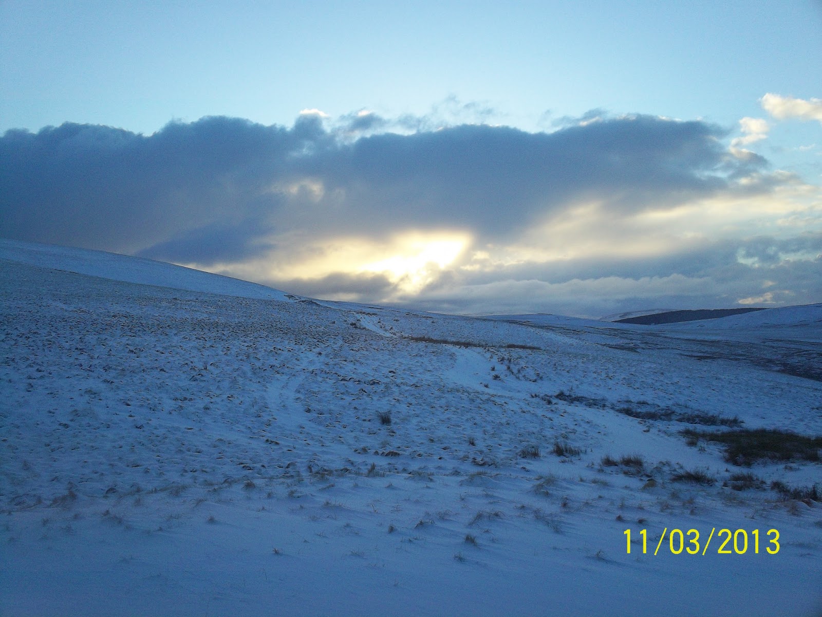
I left around 8,when on the road I noticed the bunglelow door open and the dog come trotting out, I waved to my unseen hosts and continued,  walking the short distance  over the River North Tyne and into Bellingham. It was a bright day , which hurt my head. My instinct was to follow the road into the village, but the Pennine posts stated otherwise, directing me along a newly laid path next to the River, it felt like I was taking the back door into the village. It took me abit of time to get my bearings as for some reason I was not sure where to go.
I found the local co-op and stocked up on Snickers, pack of 4, plus other supplies to get me over the next couple of days. I anticipated two days at the max to the finish of the Pennines, but it was weather permitting , my phone app- The Met Office - for Bellingham , Byrness and Kirk Yetholm predicted snow , great! I stocked up accordingly as this would probably be my last chance of goodies until the Kirk Y.


 I made my way out of Bellingham via road before striking off toward Blakelaw Farm.
Through the farm yard saying hello to someone exiting the house ,then on and up over toward more moorland.
Walking out of Bellingham

Looking down toward Bellingham from  Blakelaw Farm
As I continued a flurry of snow coming from the east started to fall . The route was easy and open. Heather becoming denser . The land was fairly barren , the main feature being Callerhues Crag.
Callerhues Crag

Hareshaws House approach.
I could see a cluster of conifers ahead and a dwelling, Hareshaws House. It appeared easy to get to but I found myself going into a dip with sedges, meaning wet. Probably it would of been wiser to have taken the higher ground ,but I didn't and got wet feet in the process.
I made my way on a rough track where you could see signs of heather burning for grouse. Across a road I contnued on up and over moorland with a few more flurries coming down.


I was glad that the snow was not settling at present , as conditions were ok. My head was clearing and I seemed to be making pretty good progress.
Again ahead of me was more forestry land this time of the famous Kielder Forest.There was more snow again in the shelter of the trees.


This was one of the easiest parts of the walk today , basically following the track through the forest.I had been seeing traces of another walkers prints in the snow, they may have been the chap near Cross Fell as I saw no other walker with that tread.  Badger and fox prints also cut the snow, this time I was able to see the fox that probably made the majority of prints and as always on seeing me disappeared.
There were a few short sections where the Pennines seemed  strike off into rough undergrowth which looked hardly walked , like the above, as the track followed a parallel route I stuck to that.

I passed the farm steading of Blakehopeburnhaugh, a strange name , as if the clerk doing the census had forgotten to put in spaces between the words. This place seem to mark the coming out into civilisation again. It was gone 2 , stopping in the sun by the closed toilets, of course the sun shone where the cold wind blew, so the sun did not warm me how I would of wanted. 
The route took me through mixed wood beside  the River Rede , passed a caravan park and out to a cluster of dwellings at Byrness. I had looked on the phone earlier to see if the hostel was open, it was but at £25 I felt it was to expensive so carried on. I had hopes of reaching the Lamb Hill Mountain Refuge hut a few miles on and if not that it would be a pitch.

River Rede

Holy Trinity Church , Byrness
I crossed the A68 , walking along it for a short spell passed a hotel and off back into the forest on a good path. I was using the mobile informing someone, no names,  that I would be finishing tomorrow, but apparently that was not convenient due to logistics and it was better that I finished Tuesday. Yes I felt I was an inconvenience, nice to be wanted,  but had no option but to delay the finish of the Pennines by a day to fit in . I supposed I had been away for 7 months and the world does not revolve around me, and she did have monday course to go to. Hey ho! During that conversation I missed the path off to my right and met a track higher than I should. A mature woman, who seemed to be sat in meditation , woke up as I popped out of the wood, as I had her attention I asked where the Pennines went from here. It was she who told me I had missed the path , directing me down along the track. This I did having thanked her. I noticed that she was following me down the track , she probably thought that I was a pratt, which I felt, and better check I took the right route. The fact I was going into the Cheviots at this time of the day , and snow seemed to be on the tops I was surprised she did not get mountain rescue out for me such was the concern on her face.
A68

Decent path but wrong one!

It was a fairly steep climb next to woodland , some partly felled by man and some felled by the wind and blocked the path requiring  limbo dancing to get by, not easy with my pack on.The last knockings a scramble over boulders to gain Byrness Hill.
View back toward Byrness from the Hill


I was on the moorland again, at about 400 metres,   hoping it would not be to rough , wet or snowy. The height gain was steady , stretched out over the miles , no sudden steep climbs, but basically up.

I was now wanting to get on, not in the mood for sight seeing I took the route keeping height above Chew Green and its Roman Camps , viewing it at a distance from above.

With more height gained I seemed to gain more snow but not enough to slow progress and was able to get on. I reached welcome walk boards , and seemed to be following the border fence, not exactly a Hadrian's Wall but adequate .I could see more snow clad hills ahead and wondered if I would be climbing any I could see.
The usual sight of a grouse, certainly on this venture has been of it/them making haste on the wing and screaming 'human, human!' in grouse talk as they did so . Anyone would think we shot them .This  weirdo grouse decided either I was a female grouse or just was defending its territory, instead of flying away from me actually flew cackling toward me  . I was ok with it initally , snapping a few photos , but it would not bugger off and creeped me out.  I told it  to shoo but in more colourful language ,in the end  I had to make haste  with it periodically flying up to me as I tried to lose it , weird....territorial?
Friend or foe

This was the first time I had walked the Cheviots , and was a little disappointed with the flatness of it all , but that meant for easy walking. The sky and openess gave a general feeling of isolation .
It was 5.45 when I passed this post
Time was getting on , but I was pretty sure even with dipping sun that I would make it to the shelter , therefore avoiding a pitch. I was surprised to see goats grazing amongst the heather, they were not at all bothered by my presence and munched happily as I continued.
Goats in the heather
I could see the shed like structure up ahead , it was nearly 6.30 when I entered the dark interior and busied myself with gathering snow to melt and laying out gear on the bench seats that lined the walls.  I could feel the cold as I had stopped , and soon climbed into my sleeping bag with cooking stuff at hand.The temperture gauge read -3. As always it took plenty of fuel to melt the snow, but I was not short of meths and needed the rehydration, plus I had plenty of time. I had covered 23 miles today .